
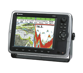
Samyung NF80 – this is a high-precision chartplotter with echo sounderequipped with a built-in global navigation satellite system GPS. This device is designed to determine the exact location of the vessel and display information about the depth of the reservoir. Thanks to the use of technologies SAMYUNG ENC and NAVIONICS, Samyung NF80 allows you to build and display three-dimensional maps.
Features:
- Color LCD display with a diagonal of 8 inches and a resolution of 800 x 600 pixels.
- Adjustable brightness display (10 levels).
- Connecting to external devices through interfaces NMEA 0183/2000.
- Support for up to 30,000 waypoints and 100 routes.
- Opportunity playback of audio and video files via USB and SD cards.
- Alarm system for warning about dangerous situations.
- Certification by the Russian Maritime Register of Shipping.
Main Features:
| Characteristic | Meaning |
|---|---|
| Display diagonal | 8 inches |
| Display Resolution | 800 x 600 pixels |
| Brightness adjustment | 10 levels |
| Echo sounder frequency | 50/200 kHz |
| Echo sounder output power | 600 W |
| Depth range | 3-1500 m |
| Operating temperature range | -10°C to +50°C |
| NMEA 0183/2000 | Yes |
| GPS receiver | Yes |
| Supply voltage | 11-35 vdc |
| Connecting external devices | USB, SD card, NMEA 0183/2000 |
| Certification process | Russian Maritime Register of Shipping |
Included in the delivery package is included:
- NF80 Card Plotter (8" TFT 800 x 480 display)
- Air navigation SAN-60
- Antenna cable (10 m)
- Power Cable
- Antenna Installation Kit
- B45 emitter (50/200 kHz)
- User's Guide
Samyung NF80 - an ideal choice for providing accurate navigation and depth monitoring, as well as for creating 3D maps in real time.
